Skip to content
Irvine Scotland
  • Home
  • The People of Irvine
  • The Irvine that was!
  • The Irvine that is!
  • The Irvine that could have been!
  • Irvine is open for business!
  • Old Parish Churchyard Project

Irvine railway station

By adminAugust 19, 2016November 30, 2018The Irvine that is
Wikipedia The Free Encyclopedia
Search
  • Create account
  • Create account
  • Log in

Pages for logged out editors learn more

  • Talk
  • Contributions

Contents

  • (Top)
  • 1History
  • 2Facilities
  • 3Services
  • 4References
    • 4.1Notes
    • 4.2Sources
  • Cymraeg
  • Nederlands
Edit links
  • Article
  • Talk
    • Read
    • View history
    • Read
    • View history
    Railway station in North Ayrshire, Scotland

    Irvine

    Scottish Gaelic: Irbhinn[1]
    National Rail
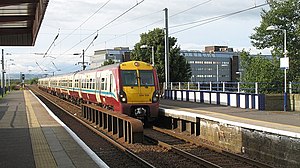
    Irvine Station - geograph.org.uk - 1625076.jpg
    General information
    LocationIrvine, North Ayrshire
    Scotland
    Coordinates55°36′42″N 4°40′30″W / 55.6116°N 4.6750°W / 55.6116; -4.6750Coordinates: 55°36′42″N 4°40′30″W / 55.6116°N 4.6750°W / 55.6116; -4.6750
    Grid referenceNS315385
    Managed byScotRail
    Transit authorityStrathclyde Partnership for Transport
    Platforms2
    Other information
    Station codeIRV
    Key dates
    5 August 1839Opened
    Passengers
    2017/18Decrease 0.996 million
    2018/19Decrease 0.912 million
    2019/20Decrease 0.889 million
    2020/21Decrease 0.114 million
    2021/22Increase 0.442 million
    Listed Building – Category C(S)
    Designated27 August 1997
    Reference no.LB44705[2]
    Notes
    Passenger statistics from the Office of Rail and Road

    Irvine railway station is a railway station serving the town of Irvine, North Ayrshire, Scotland. The station is managed by ScotRail and is on the Ayrshire Coast Line, 30 miles (48 km) south west of Glasgow Central.

    History

    The station opened on 5 August 1839 as part of the Glasgow, Paisley, Kilmarnock and Ayr Railway.[3] There was a branch leaving here for Crosshouse and Kilmarnock which closed in 1965.[4] During the electrification of the Ayrshire Coast Line by British Rail, Irvine station was partially refurbished, resulting in a glass front canopy on the main building and external ramp access to both platforms.

    Facilities

    The station is staffed on a full-time basis seven days a week.[5] There is a small kiosk shop and an adjoining car park with 100 spaces. Train running information is offered via digital CIS displays, automated announcements, timetable posters and customer help points on each platform. Step-free access is available to both sides of the station.

    Services

    Mondays to Saturdays there are 4 trains per hour northbound to Glasgow Central and 4 trains per hour southbound to Ayr with a half-hourly service in each direction on Sundays.[6]

    Preceding station National Rail National Rail Following station
    Barassie   ScotRail
    Ayrshire Coast Line
      Kilwinning
      Historical railways  
    Gailes
    Line open, station closed
      Glasgow and South Western Railway
    Glasgow, Paisley, Kilmarnock and Ayr Railway
      Bogside
    Line open, station closed
    Dreghorn
    Line and station closed
      Glasgow and South Western Railway
    Glasgow, Paisley, Kilmarnock and Ayr Railway
     

    References

    Notes

    1. ^ Brailsford 2017, Gaelic/English Station Index.
    2. ^ "NEW STREET, RAILWAY STATION". Historic Scotland. Retrieved 9 March 2019.
    3. ^ Butt, p. 128
    4. ^ Stansfield, p. 26
    5. ^ Irvine station facilitiesNational Rail Enquiries
    6. ^ Table 221 National Rail timetable, December 2016

    Sources

    • Brailsford, Martyn, ed. (December 2017) [1987]. Railway Track Diagrams 1: Scotland & Isle of Man (6th ed.). Frome: Trackmaps. ISBN 978-0-9549866-9-8.
    • Butt, R. V. J. (October 1995). The Directory of Railway Stations: details every public and private passenger station, halt, platform and stopping place, past and present (1st ed.). Sparkford: Patrick Stephens Ltd. ISBN 978-1-85260-508-7. OCLC 60251199. OL 11956311M.
    • Stansfield, G. (1999). Ayrshire & Renfrewshire's Lost Railways. Ochiltree: Stenlake Publishing. ISBN 1-8403-3077-5.
    Railway stations served by ScotRail
    Stations listed in italics are request stops.
    A
    • Aberdeen
    • Aberdour
    • Achanalt
    • Achnasheen
    • Achnashellach
    • Addiewell
    • Airbles
    • Airdrie
    • Alexandra Parade
    • Alexandria
    • Alloa
    • Alness
    • Altnabreac
    • Anderston
    • Annan
    • Anniesland
    • Arbroath
    • Ardgay
    • Ardlui
    • Ardrossan Harbour
    • Ardrossan South Beach
    • Ardrossan Town
    • Argyle Street
    • Arisaig
    • Armadale (West Lothian)
    • Arrochar & Tarbet
    • Ashfield
    • Attadale
    • Auchinleck
    • Aviemore
    • Ayr
    B
    • Baillieston
    • Balloch
    • Balmossie
    • Banavie
    • Barassie
    • Bargeddie
    • Barnhill
    • Barrhead
    • Barrhill
    • Barry Links
    • Bathgate
    • Bearsden
    • Beasdale
    • Beauly
    • Bellgrove
    • Bellshill
    • Bishopbriggs
    • Bishopton
    • Blackridge
    • Blair Atholl
    • Blairhill
    • Blantyre
    • Bogston
    • Bowling
    • Branchton
    • Breich
    • Bridge of Allan
    • Bridge of Orchy
    • Bridgeton
    • Brora
    • Broughty Ferry
    • Brunstane
    • Burnside
    • Burntisland
    • Busby
    C
    • Caldercruix
    • Cambuslang
    • Camelon
    • Cardenden
    • Cardonald
    • Cardross
    • Carfin
    • Carlisle
    • Carluke
    • Carmyle
    • Carnoustie
    • Carntyne
    • Carrbridge
    • Carstairs
    • Cartsdyke
    • Cathcart
    • Charing Cross (Glasgow)
    • Chatelherault
    • Clarkston
    • Cleland
    • Clydebank
    • Coatbridge Central
    • Coatbridge Sunnyside
    • Coatdyke
    • Connel Ferry
    • Conon Bridge
    • Corkerhill
    • Corpach
    • Corrour
    • Cowdenbeath
    • Craigendoran
    • Crianlarich
    • Croftfoot
    • Crookston
    • Crosshill
    • Crossmyloof
    • Croy
    • Culrain
    • Cumbernauld
    • Cupar
    • Curriehill
    D
    • Dalgety Bay
    • Dalmally
    • Dalmarnock
    • Dalmeny
    • Dalmuir
    • Dalreoch
    • Dalry
    • Dalwhinnie
    • Dingwall
    • Drem
    • Drumchapel
    • Drumfrochar
    • Drumgelloch
    • Drumry
    • Duirinish
    • Duke Street
    • Dumbarton Central
    • Dumbarton East
    • Dumbreck
    • Dumfries
    • Dunbar
    • Dunblane
    • Duncraig
    • Dundee
    • Dunfermline City
    • Dunfermline Queen Margaret
    • Dunkeld & Birnam
    • Dunlop
    • Dunrobin Castle
    • Dyce
    E
    • East Kilbride
    • Easterhouse
    • Edinburgh Gateway
    • Edinburgh Park
    • Edinburgh Waverley
    • Elgin
    • Eskbank
    • Exhibition Centre
    F
    • Fairlie
    • Falkirk Grahamston
    • Falkirk High
    • Falls of Cruachan
    • Fauldhouse
    • Fearn
    • Forres
    • Forsinard
    • Fort Matilda
    • Fort William
    G
    • Galashiels
    • Garelochhead
    • Garrowhill
    • Garscadden
    • Gartcosh
    • Garve
    • Georgemas Junction
    • Giffnock
    • Gilshochill
    • Girvan
    • Glasgow Central
    • Glasgow Queen Street
    • Gleneagles
    • Glenfinnan
    • Glengarnock
    • Glenrothes with Thornton
    • Golf Street
    • Golspie
    • Gorebridge
    • Gourock
    • Greenfaulds
    • Greenock Central
    • Greenock West
    • Gretna Green
    H
    • Hairmyres
    • Hamilton Central
    • Hamilton West
    • Hartwood
    • Hawkhead
    • Haymarket
    • Helensburgh Central
    • Helensburgh Upper
    • Helmsdale
    • High Street (Glasgow)
    • Hillfoot
    • Hillington East
    • Hillington West
    • Holytown
    • Howwood
    • Huntly
    • Hyndland
    I
    • Insch
    • Invergordon
    • Invergowrie
    • Inverkeithing
    • Inverkip
    • Inverness
    • Invershin
    • Inverurie
    • Irvine
    J
    • Johnstone
    • Jordanhill
    K
    • Keith
    • Kelvindale
    • Kennishead
    • Kildonan
    • Kilmarnock
    • Kilmaurs
    • Kilpatrick
    • Kilwinning
    • Kinbrace
    • Kinghorn
    • King's Park
    • Kingsknowe
    • Kingussie
    • Kintore
    • Kirkcaldy
    • Kirkconnel
    • Kirkhill
    • Kirknewton
    • Kirkwood
    • Kyle of Lochalsh
    L
    • Ladybank
    • Lairg
    • Lanark
    • Langbank
    • Langside
    • Larbert
    • Largs
    • Larkhall
    • Laurencekirk
    • Lenzie
    • Leuchars
    • Linlithgow
    • Livingston North
    • Livingston South
    • Loch Awe
    • Loch Eil Outward Bound
    • Lochailort
    • Locheilside
    • Lochgelly
    • Lochluichart
    • Lochwinnoch
    • Longniddry
    M
    • Mallaig
    • Markinch
    • Maryhill
    • Maxwell Park
    • Maybole
    • Merryton
    • Milliken Park
    • Milngavie
    • Monifieth
    • Montrose
    • Morar
    • Mosspark
    • Motherwell
    • Mount Florida
    • Mount Vernon
    • Muir of Ord
    • Muirend
    • Musselburgh
    N
    • Nairn
    • Neilston
    • New Cumnock
    • Newcraighall
    • Newton (Lanark)
    • Newtongrange
    • Newtonmore
    • Newton-on-Ayr
    • Nitshill
    • North Berwick
    • North Queensferry
    O
    • Oban
    P
    • Paisley Canal
    • Paisley Gilmour Street
    • Paisley St James
    • Partick
    • Patterton
    • Perth
    • Pitlochry
    • Plockton
    • Pollokshaws East
    • Pollokshaws West
    • Pollokshields East
    • Pollokshields West
    • Polmont
    • Port Glasgow
    • Portlethen
    • Possilpark & Parkhouse
    • Prestonpans
    • Prestwick International Airport
    • Prestwick Town
    • Priesthill & Darnley
    Q
    • Queens Park (Glasgow)
    R
    • Rannoch
    • Renton
    • Robroyston
    • Rogart
    • Rosyth
    • Roy Bridge
    • Rutherglen
    S
    • Saltcoats
    • Sanquhar
    • Scotscalder
    • Scotstounhill
    • Shawfair
    • Shawlands
    • Shettleston
    • Shieldmuir
    • Shotts
    • Singer
    • Slateford
    • South Gyle
    • Spean Bridge
    • Springburn
    • Springfield
    • Stepps
    • Stevenston
    • Stewarton
    • Stirling
    • Stonehaven
    • Stow
    • Stranraer
    • Strathcarron
    • Stromeferry
    • Summerston
    T
    • Tain
    • Taynuilt
    • Thornliebank
    • Thorntonhall
    • Thurso
    • Troon
    • Tulloch
    • Tweedbank
    • Tyndrum Lower
    U
    • Uddingston
    • Uphall
    • Upper Tyndrum
    W
    • Wallyford
    • Wemyss Bay
    • West Calder
    • West Kilbride
    • Wester Hailes
    • Westerton
    • Whifflet
    • Whinhill
    • Whitecraigs
    • Wick
    • Williamwood
    • Wishaw
    • Woodhall
    Y
    • Yoker
    Rail transport in the United Kingdom
    source: https://en.wikipedia.org/wiki/Irvine_railway_station
    Facebook Comments

    Share this:

    • Click to share on Twitter (Opens in new window)
    • Click to share on Facebook (Opens in new window)

    Related

    Post navigation

    The Big Idea (museum)
    Irvine Burns Club

    Search

    Site Updates

    • Old Parish Churchyard Project
    • Irvine Logo
    • New Videos in Articles
    • Edgar Allan Poes links to Irvine
    • Churchyard Indiegogo!

    RSS Irvine Times Headlines

    • Vineburgh boxer Matthew McDonald trains with elite Scottish group February 2, 2023
    • Plans for nine commercial units on Kirk Vennel are approved February 2, 2023
    • Stewarton Academy sees increased police presence amid behaviour fears February 2, 2023
    • MSP Michael Matheson visits Hunterston's battery storage complex February 2, 2023
    • Scottish comedian Kevin P Gilday brings fringe show to Irvine February 2, 2023
    • Dundonald man Scott Devlin jailed for abusive behaviour towards ex February 2, 2023
    • Too Good To Go: Ayrshire Aldi stores launch cheap food service February 1, 2023
    • Beyoncé Renaissance Tour 2023: Edinburgh date revealed February 1, 2023
    • Irvine Clean Up Crew member wins £500 from LitterLotto February 1, 2023
    • Crosshouse Hospital 'grateful' to receive £1,000 donation from SPAR February 1, 2023

    Events

    Site built by
    Scruffy Dug Design Solutions
    Scruffy Dug Design Solutions


    In partnership with
    Clyde Imagineering
    Clyde Imagineering
    © 2023 Irvine Scotland. Proudly powered by Sydney